Weather cameras: Safety concerns in the skies of Nepal
The dependency on phone calls and poor reporting came to a halt after the ATC officers and the pilot got access to the real-time weather details.
Share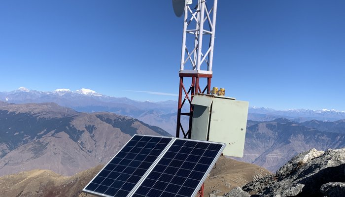
By Shila Jaisi • 2025-11-10
Flying above the magnificent Himalayan skies of Nepal has been on the bucket list of many but for a few years, it was hazardously unpredictable. The weather fluctuation, lack of proper monitoring, reliance on verbal communication, and limited technology have made aviation more like guesswork rather than a proper science. Tragically, this poor infrastructure resulted in various devastating accidents, costing several lives and making aviation riskier day by day. Here, we delve into how weather cameras, a project led by the National Innovation Center (NIC) have been transforming Nepal’s Aviation, saving lives and ensuring safer, predictable routes.
For many years, the Civil Aviation Authority of Nepal (CAAN) operated flights from major cities to the remote Himalayan regions with limited technological support, relying primarily on direct communication between air traffic controllers (ATCs) at both ends. Decisions about whether a flight could proceed were often based on verbal reports about the clarity of the route, weather conditions, and visibility. Without access to real-time data or advanced monitoring systems, this system was far from ideal: resulting in fluctuation, turbulence, and uncertainty in the Himalayas. To gather additional information, ATC officers sometimes reached out to the locals living along the flight path to get a sense of current weather and visibility. While this approach helped fill some gaps, it also left much to chance. Unfortunately, this lack of modern infrastructure has led to tragic plane crashes over the years, taking many lives and making flying in Nepal’s skies perilous.
The Tara Air Flight 197, en route from Pokhara to Jomsom, tragically crashed on May 29, 2022. Before operating the flight, they’d only followed the report from the pilot from another flight Summit Air's 9N-AKZ that took before it, flippant of the critical weather conditions around Lete and Tatopani, later led to the accident. Post-incident, safety concerns grew and that’s when weather cameras came to the implementation.
Nepal’s remote region initially lacked en-route weather monitoring systems, posing significant risks to aviation. Although the concept of weather cameras for real-time weather visibility had been proposed earlier by Dr. Mahabir Pun during his work on the Nepal Wireless Project, it was not acknowledged by the Civil Aviation Authority of Nepal (CAAN) at the time. However, as crashes due to en-route weather fluctuations increased, CAAN recognized the urgent need for such technology. The responsibility for implementing the weather camera system was entrusted to the National Innovation Center (NIC). The first installation was carried out at Mohare Danda, a relay point for the Nepal Wireless Networking Project as well.
The dependency on phone calls and poor reporting came to a halt after the ATC officers and the pilot got access to the real-time weather details. This results in a significant rise in assuring decision-making and flight safety. After the successful operation in the Pokhara-Jomsom route, CAAN recognized its usefulness in expanding the project nationwide. This initiative, which began with the Pokhara-Jomsom route, now covers safer flights across some other critical routes such as Kathmandu-Lukla, and Nepalgunj to almost every district of Karnali. With the weather cameras delivering real-time updates about cloud positioning and weather conditions in the area, pilots now can fly with more clarity, ATC officers can perform decision-making more confidently and passengers can benefit from safer flights. After the implementation, the number of crashes caused by weather uncertainty has gradually decreased making flight safety more prominent and paving a secure future for Nepal Aviation.
Currently, the cameras installed across those various routes provide precise reports daily, initiating clarity for the day only. However, the NIC team has been gearing up on a broad aspect taking weather monitoring to another level as the system’s capabilities are limited to live updates with no sense for future data and weather forecasts for upcoming situations.
With a comprehensive collection of data collected over all the seasons, the plan is to process and analyze those data to build an accurate weather forecast. This initiative focuses on predicting the weather conditions for the next three days or even offers predictions for a specific day and time zone. This would help in providing backup in case of system failure, ensuring the operation remains safe and unaffected.
The new initiative is all set to revolutionize the way weather data is utilized, facilitating pilots, and ATC officers with a greater sense of clarity and confidence, and also protecting passengers from any harm. By integrating real-time data with predictive analytics, NIC is paving the way for a safer, innovative, and efficient future in aviation.

Help us turn innovative ideas into marketable products.
Support and be a Part of this innovation
Contribute to this innovationArticles/News
View more
Support and be a Part of this great innovation
Help us turn innovative ideas into marketable products.
Contribute